Lebanon Interchange Land Use Plan
![]() Watchdog Indiana Home Page
Watchdog Indiana Home Page
![]() Watchdog Lebanon Home Page
Watchdog Lebanon Home Page
![]() Lebanon
Interchange Land Use Plan Landowners
Lebanon
Interchange Land Use Plan Landowners ![]() Huck
Lewis Campaign Contributions History
Huck
Lewis Campaign Contributions History ![]() Lebanon
Indianapolis Avenue "Gateway" Project
Lebanon
Indianapolis Avenue "Gateway" Project ![]() Lebanon
SR 39 Bridge "Gateway" Project
Lebanon
SR 39 Bridge "Gateway" Project ![]() Lebanon
I-65 Corridor Annexation
Lebanon
I-65 Corridor Annexation ![]() Lebanon
!-65 Corridor Master Drainage Plan
Lebanon
!-65 Corridor Master Drainage Plan ![]() Lebanon
Utilities 2012 Electric Rate Increase
Lebanon
Utilities 2012 Electric Rate Increase
Summary
Some aspects of the City of Lebanon Interchange Land Use Plan might be a reasonable road map for orderly development the next few decades. However, the Interchange Plan provisions that call for the $109.125 million estimated cost of the recommended infrastructure to be shared by Lebanon taxpayers and utility ratepayers are Taxpayer UNfriendly and would rapidly erode our rural quality of life while creating the potential for eminent domain abuses. Also, the Interchange Plan does not preserve Center Township farmland as provided for in the Boone County Area Comprehensive Plan. The Interchange Plan should be tabled by the Lebanon Plan Commission unless and until (1) all Interchange Plan references are removed that relate to infrastructure cost sharing by taxpayers and utility ratepayers and (2) the 1,000 acres of Center Township farmland are removed from the Interchange Plan's study area.
CURRENT STATUS: A public hearing was held for the Interchange Plan on April 21, 2014, by the Lebanon Plan Commission. At the conclusion of the Plan Commission public hearing, it was announced that the Plan Commission would not approve the Interchange Plan at the April 21, 2014, meeting. No subsequent formal City of Lebanon action has been taken to amend the Lebanon Comprehensive Plan to include the Interchange Plan.
Lebanon Enterprise Boulevard Extension
On November 2, 2015, the Lebanon Redevelopment Commission rubber-stamped (without dissent) a $482,280 no-bid contract for American Structurepoint to provide engineering services for the following extension of Enterprise Boulevard a total of 1.4 miles between State Road 39 and Hall Baker Road:
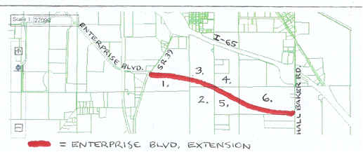
1. Property Address: 645 S. SR 39 – Acreage: 82.63 – Owner Name: HRP
Holdings LLC – Owner Address: 1008 Essex Court, Lebanon, IN 46052 (residence
of Sharon Lee Powell)
2. Property Address: 801 S. John Shaw Road (Est.) – Acreage: 70.65 – Owner
Name: HRP Holdings LLC – Owner Address: 1008 Essex Court, Lebanon, IN 46052
(residence of Sharon Lee Powell)
3 & 4. Property Address: 625 S. John Shaw Road – Acreage: 99.81 – Owner
Name: Tyre Home Place Farm LLC – Owner Address: 130 Ulen Boulevard, Lebanon,
IN 46052 (residence of Charlotte and Kent Frandsen)
5. Property Address: 1101 S. John Shaw Road (Est.) – Acreage: 35 – Owner
Name: Tyre Home Place Farm LLC – Owner Address: 130 Ulen Boulevard, Lebanon,
IN 46052 (residence of Charlotte and Kent Frandsen)
6. Property Address: 1140 S. CR 100 E. – Acreage: 79.28 – Owner Name:
Donovan Eugene Harlos Residuary Trust – Owner Address: 1080 S. CR 100 E.,
Lebanon, IN 46052 (residence of Eugene and Helen Harlos)
This Enterprise Boulevard extension was yet another example of the Developer Friendly manipulations of outgoing Mayor Huck Lewis that was poor public policy for the reasons listed next.
(1) The Enterprise Boulevard extension, whose total cost is expected to be at least $9.6 million, is part of the $109.125 million in infrastructure improvements included in the Lebanon Interchange Land Use Plan: see the "Taxpayer and Utility Ratepayer Subsidized Infrastructure" heading below on this web page. There is supposed to be retail, industrial, multi-family residential, single-family residential, and office development along the Enterprise Boulevard extension. However, the extension is just another costly build-it-and-they-will-come proposal where no developer partner has been identified.
(2) The Lebanon Interchange Land Use Plan includes a water main to be installed along the Enterprise Boulevard extension. Just how much will Lebanon Utilities water bills increase to pay for a new 1.4-mile water main that is expected to cost at least $2 million?
(3) The Lebanon Interchange Land Use Plan has been prepared in secret, its merits and shortcomings have not been thoroughly debated, and it has not been properly adopted by the city as part of the Comprehensive Plan.
(4) Did American Structurepoint receive the $482,280 no-bid engineering services contract because they were the number one campaign contributor to the Friends of Huck Lewis: see http://www.finplaneducation.net/huck_lewis_contributions.htm?
(5) Kent Frandsen, who is a Partner with the Parr, Richey, Obremsky, Frandsen & Patterson law firm, was one of the 14 persons who secretly prepared the Lebanon Interchange Land Use Plan. Mr. Frandsen’s wife, Charlotte, is identified as the Principal for Tyre Home Place Farm LLC that owns parcels of land along the Enterprise Boulevard extension at 625 and 1101 South John Shaw Road that total 134.81 acres. Tax abatement legal services generate significant income for Mr. Frandsen, and the Interchange Plan anticipates that the study area will be designated an Economic Development Area so businesses that locate or expand in the area can receive tax incentives. Also, the value of land owned by Tyre Home Place Farm LLC would be increased if infrastructure is provided for the land by taxpayers and utility ratepayers. Furthermore, Parr Richey has been a significant campaign contributor to the Friends of Huck Lewis. Mr. Frandsen is sincere in his desire to do what he thinks is right for Lebanon, but is it proper for Mr. Frandsen to be so involved with preparing a land use proposal where he is likely to personally benefit?
(6) Sharon Powell of HRP Holdings LLC, who was one of the 14 persons who secretly prepared the Lebanon Interchange Land Use Plan, owns two parcels of land along the Enterprise Boulevard extension at 645 South State Road 39 and 801 South John Shaw Road that total 153.28 acres. In a February 3, 2011, Zionsville Times Sentinel article Ms. Powell said she’d like to see infrastructure improvements in areas that have been annexed by local governments over the past five years. Perhaps she is a strong supporter of the Interchange Plan because the value of her land would be increased if infrastructure is provided at taxpayer and utility ratepayer expense. Is it proper for Ms. Powell to be so involved with preparing a land use proposal where she is likely to personally benefit?
The $482,280 no-bid engineering services contract with American Structurepoint contains a clause that allows the contract to be terminated with 30 days notice. Perhaps the new incoming Mayor Matt Gentry will care enough about Lebanon’s taxpayers and utility ratepayers to stop the Enterprise Boulevard extension at least until a developer partner is identified to share the costs for the grandiose proposals included in the Lebanon Interchange Land Use Plan.
Pertinent Interchange Plan Documents
August 6, 2013, City of Lebanon Interchange Land Use Plan “draft” document: http://www.booneedc.org/media/cityoflebanon0806draftweb1.pdf..
February 2014 I-65 / SR 39 Interchange Land Use Plan “draft plan summary” slide presentation: http://www.booneedc.org/media/cityoflebanon0806draftweb2.pdf.
Watchdog Lebanon "Lebanon I-65 Corridor Master Drainage Plan" web page: http://www.finplaneducation.net/lebanon_drainage_plan.htm.
Updated version of the Lebanon I-65 Corridor Master Drainage Plan that was presented to the Boone County Drainage Board on October 21, 2013, and the Lebanon City Council on October 28, 2013: https://cbbel-in.sharefile.com/d/sd2a5724d0bb44afa (please send an E-mail to taxless3@comcast.net and ask for E-mail attachments if you have difficulty opening the two documents on this web page).
Boone County Area Comprehensive Plan: http://www.boonecounty.in.gov/Default.aspx?tabid=65.
PETITION REQUEST TO LEBANON MAYOR HUCK LEWIS
All Lebanon and Boone County residents concerned about Lebanon's I-65 and State Road 39 Interchange Land Use Plan are encouraged to sign the "PETITION REQUEST TO LEBANON MAYOR HUCK LEWIS."
Please send an E-mail to taxless3@comcast.net to obtain a copy of the Petition.The Petition reads as follows: "The signature(s) of the concerned citizen(s) on this petition verify a request to have the 1,000 Acres of unincorporated Center Township farmland removed from the proposed City of Lebanon I-65 and State Road 39 Interchange Land Use Plan. Some of the reasons for this request include the following: (1) the industrial and single family residential land uses included in the Interchange Plan for the 1,000 Acres conflict with the Boone County Area Comprehensive Plan that preserves agricultural uses until the year 2030, (2) the Boone County Zoning Ordinance as administered by the Area Plan Commission satisfactorily protects the 1,000 Acres from "spot zoning" changes without the Interchange Plan, (3) the 1,500 acres in the Interchange Plan study area that are already within the Lebanon city limits are sufficient for Lebanon’s commercial and industrial development the next twenty years without the 1,000 Acres in unincorporated Center Township, (4) Lebanon has plenty of empty buildings and space in the Lebanon Business Park for business development without the 1,000 Acres, (5) inclusion of the 1,000 Acres in the Interchange Plan might defeat in court a land owners remonstrance against a future involuntary Lebanon annexation, (6) it would be more likely for eminent domain to be imposed to forcibly obtain the rights-of-way needed for the proposed Interchange Plan infrastructure, (7) the rural quality of life that so many Boone County residents enjoy and cherish would be maintained."
Overview
The City of Lebanon FINALLY divulged to concerned citizens on February 18, 2014, that the pertinent Interchange Land Use Plan documents can be found online at the Boone County Economic Development Corporation website. The August 6, 2013, City of Lebanon Interchange Land Use Plan “draft” document can be found online at http://www.booneedc.org/media/cityoflebanon0806draftweb1.pdf. The February 2014 I-65 / SR 39 Interchange Land Use Plan “draft plan summary” slide presentation can be found online at http://www.booneedc.org/media/cityoflebanon0806draftweb2.pdf. Please send an E-mail to taxless3@comcast.net if you would like to receive by return E-mail a PDF copy of both Interchange Plan documents for downloading to your computer. The documents can also be downloaded directly from the Boone County Economic Development Corporation website.
The Interchange Plan “outlines the City’s short- to long-term plan for improvement, development, and growth” for a study area whose northeast boundary is I-65, west boundary is SR 39, and south boundary is County Road 250 South.” The Interchange Plan is presented as a “foundation for future decision-making regarding land use and infrastructure development and transportation circulation.” The Interchange Plan states, “Growth within the study area is desired to be in the form of mid- to high-end residential, business, office, retail, technology, research, light industry, or a combination of these forms.”
The Interchange Plan further states, “Zoning classifications within the study area do not change.” The Interchange Plan “suggests long-term uses within the study area that may or may not be consistent with existing zoning classifications.” The suggested land uses “do not represent a presumptive guarantee of any future zoning approval.” However, the Interchange Plan also states that it “provides a basis for updating City zoning and the Comprehensive Plan” and “the expectation is that this Plan will ultimately be adopted as an amendment” to the 2007 City of Lebanon Comprehensive Plan.
Interchange Plan Study Area Description
The study area is about 2,500 acres, with 1,500 acres within the City and 1,000 acres outside the City. Agricultural land in the study area today totals 2,190 acres and is “actively used by a select number of owners that have held the properties for several generations.” Natural areas now total 125 acres and are comprised of “wooded lots, water bodies, waterways, designated floodplains, and designated wetlands.” Thirty single-family residential use parcels total 120 acres. The Boone County Airport, which serves 7,000 aircraft operations per year, uses 30 acres. A now-vacant hotel property at the I-65 and SR 39 interchange and a storage unit facility at Hall Baker Road comprise 20 acres. An old lumber distribution yard near SR 39 sits on 10 acres. A cemetery on John Shaw Road covers 5 acres.
The Interchange Plan allocates 1,975 acres of the 2,500 acres in the study area to the seven districts described in the following paragraphs. (It is uncertain why the Plan does not list 525 acres as allocated; all 2,500 acres in the study area are allocated to a district on the maps that accompany the Plan.)
(1) Single Family Residential District. 740 acres. “Cluster housing and planned unit developments should be encouraged” that “are expected to be high-quality and mid- to high-end to diversify the single family residential product types in Lebanon.”
(2) Industrial District. 570 acres. A “mix of uses (including manufacturing, assembly, service, research and development, distribution, and wholesale establishments) that are relatively clean, quiet, and free of hazardous or objectionable elements” are envisioned along the rail line east of SR 39 and north of CR 250 S.
(3) Office District. 230 acres. The Plan “focuses on a mix of office parks, and could cater to customer service/support centers, accounting firms, law firms, and insurance offices that service the immediate area.”
(4) Conservation District. 150 acres. “Natural areas not suitable for development (for reasons of being a cemetery, floodplain, nature preserve, wetland, water body, and/or steep terrain)” are preserved.
(5) Multi-Family Residential District. 130 acres. “High-quality and market rate” development is expected “to diversify the multi-family residential product in Lebanon.”
(6) Special Use District. 100 acres. This district includes the Boone County Airport and the Brookshire Arboretum (which is a “10-acre site with substantial tree coverage”).
(7) Commercial/Retail District. 55 acres. The focus is on “upscale oriented, mom-and-pop themed, and park-once strategies” that are “pedestrian-friendly” with “high architectural standards.” “Larger anchors such as Gander Mountain or Target” are desired along with “higher quality, and smaller local shops” such as “specialty grocery stores, restaurants, and home improvement or art related businesses.” There should be “a different mix from what is found near Lebanon’s other three interchanges.” The “quick serve/fast food, highway related convenience businesses” should be avoided and truck stops “should be discouraged.”
Taxpayer and Utility Ratepayer Subsidized Infrastructure
Some residents treasure Lebanon as a bedroom community with a wonderful rural quality of life, and want Taxpayer Friendly growth that is orderly and pays for itself without taxpayer and utility ratepayer subsidy.
Other Lebanon residents believe it is desirable to pursue Fishers-like growth that is developer-friendly and subsidized by City tax and utility rate increases.
The Interchange Plan appeals to those who favor developer-friendly growth. The Interchange Plan supports taxpayer and utility ratepayer subsidized build-it-and-they-will-come infrastructure improvements by stipulating: (a) “The cost of the recommended infrastructure is intended to be shared by Lebanon as well as the developer” and (b) “All infrastructure developments will defray development costs associated with private developments and make the study area more attractive for private investment, as well as reduce the risk and time for development.” The Interchange Plan further states that only “secondary streets and access drives, in addition to individual site utilities and laterals, should remain the responsibility of private development.”
Nine categories of infrastructure subject to taxpayer and utility ratepayer subsidies are included in the Interchange Plan.
(1) New roads totaling 3.9 miles would become 4-lane “primary collector and arterial streets.” Using the American Structurepoint $12.420 million estimate to construct 1.82 miles of 4-lane arterial road between CR 300 S and CR 400 S as a guide, the 3.9 miles of 4-lane subsidized road construction would total $26.614 million.
(2) New roads totaling 2.5 miles would become 2-lane “primary collector and arterial streets.” Using the American Structurepoint $5.838 million estimate to construct 1.82 miles of 2-lane collector road between CR 300 S and CR 400 S as a guide, the 2.5 miles of 2-lane subsidized road construction would total $8.019 million.
(3) New roads totaling 5.3 miles would become 3-lane “primary collector and
arterial streets.” Using a midpoint of $9.129 million between the American
Structurepoint estimates of $10.420 million to construct 1.82 miles of 4-lane
arterial road and $5.838 million to construct 1.82 miles of 2-lane collector
road between CR 300 S and CR 400 S as a guide, the 5.3 miles of 3-lane
subsidized road construction would total $26.584 million.
(4) Water main line infrastructure improvements are proposed within the
“primarily existing public right of way” along 6.1 miles of planned primary
collector and arterial roads. It was revealed at the September 16 Lebanon Storm
Water Management Board meeting that constructing new 8 and 12 inch water lines
along 0.6 mile of Meridian Street will cost $860,000 – using this project as
typical for the Interchange Plan study area, the 6.1 miles of proposed water
main lines would cost $8.743 million.
(5) Sanitary sewer trunk lines would be constructed along 5.8 miles of planned
primary collector and arterial roads. Using as a guide the Lebanon Utilities
estimate that 3,359 feet of 8-inch sewer line and 17 manholes for the
Indianapolis Avenue “gateway” project will cost $193,860, it would cost
$1.767 million for 5.8 miles of similar sanitary sewer trunk lines.
(6) Sanitary “lift stations near the intersections of CR 150 S and John Shaw Road and CR 250 S and CR 100 E” would be constructed. Since it was reported at the February 5 Lebanon Utility Service Board meeting that the new Prairie Heights lift station will cost $1,243,202, it can be estimated that the cost of the two lift stations would be $2.486 million.
(7) “Electric recommendations include a transmission line
generally following CR 150 S between CR 100 E and SR 39." It was reported
at the October 23 Lebanon Utility Service Board meeting that the transmission
line project will cost $4.200 million.
(8) The Interchange Plan also includes "an electric substation at SR 39 and
CR 150 S.” Documentation for the recent Lebanon Utilities $13 million bond
issue estimates the substation will cost $1.910 million.
(9) The Plan “recommends the utilization of (stormwater) regional detention in
this area for drainage as well as to reduce private on-site detention
facilities.” Of the $28.802 million total cost for the Lebanon I-65 Corridor
Master Drainage Plan, the Boone County Drainage Board would be responsible for
$23.384 million and the Lebanon Storm Water Management Board would cover $5.418
million. On January 13, the Lebanon Storm Water Management Board awarded a
$132,000 no-bid contract to Christopher B. Burke Engineering to design a 28-acre
detention pond north of the Sanitary Ditch.
The cost estimates summary for the Interchange Plan’s nine categories of
infrastructure subject to taxpayer and utility ratepayer subsidies is as
follows:
$ 26.614 million for 3.9 miles of 4- lane Arterial Roads
$ 8.019 million for 2.5 miles of 2-lane Collector Roads
$ 26.584 million for 5.3 miles of 3-lane Roads
$ 8.743 million for 6.1 miles of Water Main Lines
$ 1.767 million for 5.8 miles of Sanitary Sewer Trunk Lines
$ 2.486 million for 2 Sanitary Lift Stations
$ 4.200 million for an Electric Transmission Line
$ 1.910 million for an Electric Substation
$ 28.802 million for the Lebanon I-65 Corridor Master Drainage Plan
$109.125 million TOTAL Subject to Taxpayer and Utility Ratepayer Subsidies
To put the $109,125,000 total Interchange Plan infrastructure subject to taxpayer and utility ratepayer subsidies in perspective, the total 2014 City of Lebanon budget certified by the Indiana Department of Local Government Finance is $12,762,558. Mayor Lewis expresses his municipal growth philosophy in the City of Lebanon April 2014 Newsletter when he states, “Many entities are reluctant to locate in Lebanon without being ‘offered’ something.” Lebanon and Boone County working families cannot afford the mayor’s desired quid pro quo for the Interchange Plan infrastructure.
The Interchange Plan MIGHT be acceptable if there were a mayor and high-quality development partner willing to work together to provide infrastructure improvements without imposing tax and utility rate increases on hard-pressed citizens. There are two nearby examples of good development partnerships. The prior Lebanon mayor had a good working relationship with Duke Realty where identified business prospects built quickly enough within the Lebanon Business Park tax increment financing (TIF) district so that taxpayers and utility ratepayers weren’t stuck with the bill for infrastructure improvements. Also, even though the Anson TIF districts have not developed quickly enough for the TIF revenue to make all the principal and interest payments on $32.025 million of infrastructure bonds, taxpayers and utility ratepayers have not paid for the shortfall because Duke Realty signed an agreement with the Boone County Redevelopment Commission to make the debt service payments when the TIF revenue is insufficient. There is no Interchange Plan development partner with identified business prospects who is willing to sign an agreement so taxpayers and utility ratepayers don’t have to pay for infrastructure improvements.
About one fourth of the 2012 Lebanon Utilities 14.44% electric rate increase on residential customers was for debt service on a $13 million bond issue. This bond issue was supposed to provide $2.155 million for electric transmission lines and $1.910 million for an electric substation within the Interchange Plan study area. However, there has already been a cost overrun on the transmission lines project – current estimates increase the cost of this project from $2.155 million to $4.200 million. The 95% cost overrun on the transmission lines project will likely result in Lebanon Utilities wanting another electric rate increase.
No private sector development partner has been identified, and no infrastructure impact fee structure is in place, to recoup any of the taxpayer and utility ratepayer infrastructure subsidies included in the Interchange Plan. The Interchange Plan points out, "Studies have been completed for park and infrastructure impact fees but have never been adopted. Adoption of the structure should be completed to ensure new development does not have a negative impact on Lebanon's parks, public services and infrastructure."
Boone County Area Comprehensive Plan Conflict
The Lebanon Interchange Land Use Plan declares that the documents “used to inform” its recommendations were the 2007 City of Lebanon Comprehensive Plan, 2009 Boone County Area Comprehensive Plan, 2006 Center Township Thoroughfare Plan, 2009 Lebanon Gateway Study, and 2013 Lebanon I-65 Corridor Master Drainage Plan. The Plan also notes that “the City of Lebanon has designated a 1,000-foot Overlay Zone along the I-65 corridor” and “a similar Overlay Zone has been established for the SR 39 corridor.”
The long-term uses proposed by the Lebanon Interchange Land Use Plan for the 1,000 acres of the study area located in Center Township (outside the Lebanon city limits) are in conflict with the Boone County Area Comprehensive Plan.
The Center Township future land-use map is presented and described on Pages 111 and 112 of the Boone County Area Comprehensive Plan, which can be found online at http://www.boonecounty.in.gov/LinkClick.aspx?fileticket=3SHSjB9Aa78%3d&tabid=65&mid=1495.
The Boone County Area Comprehensive Plan, which identifies the desired future land uses in Center Township until the year 2030, retains agricultural land uses for almost all of the 1,000 acres in the study area. The small remainder of the study area within Center Township includes an airport district (adjacent to the Boone County Airport) that "may be appropriate for new residential and mixed-use residential development, especially in the form of an aviation subdivision that is a residential area targeted to people who own and pilot small aircraft." The map below depicts the desired future land uses until the year 2030 included in the county's Comprehensive Plan for the 1,000 acres of the study area located in Center Township.
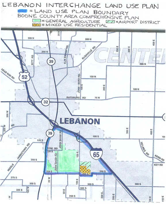
The land use districts proposed by the Lebanon Interchange Land Use Plan for the 1,000 acres of the study area located in Center Township are not compatible with, and appropriate for, almost all of the desired future land uses identified in the Boone County Area Comprehensive Plan and depicted in the map above. The map below depicts the proposed future industrial and single family residential land uses included in the Lebanon Interchange Land Use Plan (the preservation of a few small natural areas is also proposed because "they are not suitable for development").
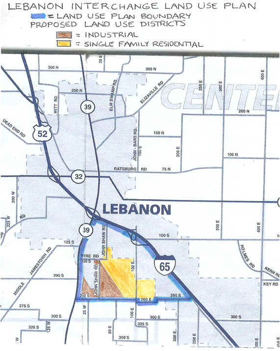
Public officials from Lebanon should work together with Boone County officials to ensure the Boone County Area Comprehensive Plan is properly taken into consideration. The Lebanon Plan Commission should table the Lebanon Interchange Land Use Plan unless the 1,000 acres of Center Township farmland are removed from the Interchange Plan's study area.
Suburban Sprawl
The Interchange Plan study area is about 2,500 acres, of which 2,190 acres are agricultural land that is “actively used by a select number of owners that have held the properties for several generations.” The Interchange Plan replaces the rural quality of life provided by the farmland with suburban sprawl contained in Single Family Residential, Industrial, Office, Multi-Family Residential, and Commercial/Retail districts.
Eminent Domain Threat
A statement included in the Interchange Plan is “the goal of (the Indianapolis Avenue gateway at I-65 exit 138) is to welcome residents and visitors to Lebanon and invite them to look further at all the great qualities of the City.” This Indianapolis Avenue gateway project highlights the eminent domain threat presented by the Interchange Plan. The City ruthlessly filed eminent domain legal proceedings against three property owners to obtain the right-of-way needed for the first phase of the nonessential and nonsensical Indianapolis Avenue gateway project (see http://www.finplaneducation.net/lebanon_eminent_domain.htm). The Interchange Plan provides the basis for the City to initiate more eminent domain proceedings against property owners in the study area who are reluctant to have their property taken for infrastructure easements and multi-acre detention ponds.
The Interchange Plan study area is about 2,500 acres, of which 2,190 acres are agricultural land that is “actively used by a select number of owners that have held the properties for several generations.” The Plan covers 1,000 acres of Center Township farmland outside the current Lebanon city limits. Center Township farmers may believe they are protected against involuntary annexation by Lebanon because our Indiana Code now provides that if a municipality annexes territory that is zoned agricultural, it may not collect property taxes for municipal purposes so long as the property retains the agricultural zoning. Indiana law also provides that an agricultural property owner must agree to any zoning change from agricultural to another zoning classification.
In spite of these legal protections against the impacts of involuntary farm annexation, the impacted Center Township farmers should still “be very afraid” of the foundation for involuntary annexation that would be presented by adoption of the Interchange Plan. Lebanon might be able to convince a court to rule against an annexation remonstrance because existence of the Interchange Plan is evidence that the 1,000 acres of Center Township farmland is needed for development in the reasonably near future.
If Lebanon annexes the 1,000 acres of Center Township farmland, it will be easier to use eminent domain to forcibly obtain the rights-of-way needed for the following infrastructure included in the Interchange Plan within the 1,000 acres: (1) 9.9 miles of new and improved roads, (2) water main lines and sanitary sewer trunk lines along the 9.9 miles of new and improved roads, (3) a sanitary lift station near the intersection of CR 150 S and John Shaw Road, (4) a sanitary lift station near the intersection of CR 250 S and CR 100 E.
The threat of eminent domain by Lebanon is very real. The Lebanon Utility Service Board at its February 19, 2014, meeting passed Resolution 2014-01 recommending that the Lebanon City Council delegate its eminent domain authority to to the Lebanon Utility Service Board to acquire farm land for substations, additional transmission lines, and related electric facilities within the Interchange Plan study area generally from State Road 39 along County Road 100 South (Tyre Road) across to County Road 100 East (Hall Baker Road) and up to County Road 100 South. The somewhat underhanded circumstances associated with the passage of Resolution 2014-01 by the Lebanon Utility Service Board are summarized next.
(1) The February 19 Utility Service Board meeting was conveniently NOT televised because of ongoing video problems.
(2) Mayor Huck Lewis conspicuously attended the portion of the February 19 Utility Service Board meeting where Resolution 2014-01 was passed.
(3) A motion was passed to read Resolution 2014-01 by title only so the phrase “eminent domain” would not be uttered publicly. James Urban made a motion to pass Resolution 2014-01 that was seconded by Allen Woods. Without any pertinent discussion, Dan Lamar, Mike Thrine, James Urban, and Allen Woods all quickly voted to pass Resolution 2014-01 (Tom Temple was absent).
(4) Jay McCoskey, Lebanon Utilities General Manage, declined a request immediately after the February 19 Lebanon Utility Service Board meeting to voluntarily provide a copy of Resolution 2014-01.
(5) A public records request was hand-delivered to the Lebanon Utilities office on February 20 asking to “inspect during your regular business hours the text of” Resolution 2014-01.
(6) Lebanon Utilities made Resolution 2014-01 available for inspection on February 21, but refused to provide a copy. Included below (under my name) is the text of Resolution 2014-01 that had to be copied by hand because Lebanon Utilities refused to provide a copy.
The Lebanon City Council should NOT delegate its authority to exercise the power of eminent domain to the Lebanon Utility Service Board to acquire private property for electric infrastructure within the Interchange Plan study area because the Interchange Plan does not meet an essential public need. Indeed, the intention of the Interchange Plan is to subsidize developers with tax and utility rate increases.
All citizens concerned about the misuse of eminent domain need to ACT NOW and insist that Mayor Huck Lewis and the Lebanon City Council refuse to unwisely delegate to the Lebanon Utility Service Board its eminent domain authority to forcibly acquire private property for electric infrastructure within the Interchange Land Use Plan study area.
Economic Development Area Designation
The Interchange Plan anticipates that the study area will be designated an Economic Development Area so businesses that locate or expand in the area can receive tax incentives, credits, or low-interest loans from local or state authorities. These business subsidies are paid for with tax dollars.
TIF District Possibility
The Interchange Plan states, “If a company is interested in a piece of property but the property is not connected to necessary infrastructure, it may be beneficial for the City to use funds from (a Tax Increment Financing district) to pay for these improvements.” Unlike the Anson TIF districts, which have Duke Realty to cover their ongoing infrastructure debt payment shortfalls, no development partner has been identified to protect Lebanon taxpayers from debt payment shortfalls in a slow-developing TIF district within the study area.
No Public Input
The 2009 Boone County Comprehensive Plan was developed using an open-door
planning approach where 173 Boone County citizens and stakeholders with a wide
variety of self-interests participated as Focus Group and Task Force members.
Twenty-two of these 173 participants also served as Steering Committee members.
Four initial public meetings were held throughout Boone County to inform the
public about the planning process along with gaining their input on important
issues. Four follow-up public meetings allowed citizens and stakeholders to
create a Boone County vision and brainstorm possible goals and objectives to
achieve the vision.
The Lebanon Interchange Land Use Plan was devised using the closed-door
“DAD” (design, advocate, defend) approach. American Structurepoint, which
was awarded a no-bid contract to be the Interchange Plan consultant, facilitated
seven Lebanon Working Group meetings from November 2012 through August 2013 that
were not open to the public. The Lebanon Working Group
was composed of the 14 persons listed next, whose interests would be well-served
by the $93.968 million of taxpayer and utility ratepayer subsidized
infrastructure proposed by the Interchange Plan.
Mike Adams is the Lebanon Utilities Electric Engineering
Manager. His job security and job satisfaction would be enhanced if utility
ratepayers pay for a $4.200 million electric transmission line and a $1.910
million electric substation within the Interchange Plan study area.
Bryan Brackemyre is the Executive Director of the Boone County
Economic Development Corporation. His job security would be improved if he gets
to work on just one more new development project within the Interchange Plan
study area, no matter how much it costs taxpayers and utility ratepayers to
provide build-it-and-they-will-come infrastructure for the benefit of
developers.
Charlie Campbell is the City of Lebanon Planning & Zoning
Director. He might be able to solidify his job status and justify his $54,091
salary by adding yet more employees to his staff if the Interchange Plan is
approved and infrastructure construction generates more activity for his
department.
Kent Frandsen is a Partner with the Parr, Richey, Obremsky,
Frandsen & Patterson law firm. Mr. Frandsen’s wife, Charlotte, is
identified as the Principal for Tyre Home Place Farm LLC that owns two parcels
of land within the Interchange Plan study area at 625 and 1101 South John Shaw
Road that total 134.81 acres. Tax abatement legal services generate significant
income for Mr. Frandsen, and the Interchange Plan anticipates that the study
area will be designated an Economic Development Area so businesses that locate
or expand in the area can receive tax incentives. Also, the value of land owned
by Tyre Home Place Farm LLC would be increased if infrastructure is provided for
the land by taxpayers and utility ratepayers.
Don Geisler is an owner of 17 parcels of land wholly or partly
within the Interchange Plan study area that total 618.04 acres. The value of
land owned by Mr. Geisler would be increased if infrastructure is provided for
the land by taxpayers and utility ratepayers.
Bob Harris is the Managing Partner of Harris Family Limited
Partnership, which received a $250,000 grant from the Zionsville Redevelopment
Commission for site development costs to construct a three-building mixed-use
center on South Main Street near 106th Street in Zionsville. Harris Family
Limited Partnership would undoubtedly welcome grants and other subsidies from
taxpayers and utility ratepayers to make any development projects within the
Interchange Plan study area more profitable.
Ray Ingham is the President and CEO of Witham Health Services.
Witham Health Services would likely profit from more patients if the taxpayer
and utility ratepayer subsidies proposed by the Interchange Plan result in a
Lebanon population increase.
Dan Lamar is an owner of Lamar & Lamar Insurance and
Chairman of the Lebanon Utilities Service Board. No matter how unlikely it is
that the taxpayer and utility ratepayer subsidies for the Interchange Plan
infrastructure would result in significant high-quality and mid- to high-end
residential development, Lamar & Lamar Insurance has little to lose from
adoption of the Interchange Plan because there is a chance to gain a few more
insurance clients.
Huck Lewis is the City of Lebanon Mayor. Mr. Lewis is
unabashedly developer-friendly, and it can be assumed he anticipates continued
extravagant campaign contributions from the businesses, business political
action committees, and business employees who benefit from local government
contracts, development subsidies, and tax abatements: see http://www.finplaneducation.net/huck_lewis_contributions.htm.
Jim Lewis is Co-Owner of Gene Lewis Ford and President of the
Lebanon Redevelopment Commission. Gene Lewis Ford might profit from more car
sales if the taxpayer and utility ratepayer subsidies proposed by the
Interchange Plan result in a Lebanon population increase.
Tom Merritt is the owner of Merritt Contracting, which provides
full-service concrete, foundation, basement, slab, and excavating services for
commercial and residential customers throughout central Indiana. Mr. Merritt is
also President of the Lebanon Community School Corporation, a non-voting member
of the Lebanon Redevelopment Commission, and is identified as a property owner
within the Interchange Plan study area. Merritt Contracting might anticipate a
greater need for its construction services if the Interchange Plan is adopted.
(Does anyone receiving this E-mail know what property is owned by Mr. Merritt
within the Interchange Plan study area? A listing of the Interchange Plan land
parcels can be found at http://www.finplaneducation.net/lebanon_interchange_landowners.htm.)
Sharon Powell of HRP Holdings LLC owns two parcels of land
within the Interchange Plan study area at 645 South State Road 39 and 801 South
John Shaw Road that total 153.28 acres. In a February 3, 2011, Zionsville
Times Sentinel article Ms. Powell said she’d like to see infrastructure
improvements in areas that have been annexed by local governments over the past
five years. She no doubt is a strong supporter of the Interchange Plan because
the value of her land would be increased if infrastructure is provided at
taxpayer and utility ratepayer expense.
Bob Taylor is the Superintendent of the Lebanon Community School
Corporation and a member of the Lebanon Redevelopment Commission. Regardless of
how much it might cost the families of the 42.2% of Lebanon students who receive
free and reduced price lunches to subsidize the Interchange Plan study area
infrastructure, the Lebanon Community School Corporation would get more money
from the state if more students were to reside within the study area.
Bob Waples is the Lebanon Utilities Water/Wastewater
Operational Manager. His job security and job satisfaction would be enhanced if
taxpayers and utility ratepayers pay $18.347 million for water main line
infrastructure, $3.901 million for sanitary sewer trunk lines, $2.486 million
for two sanitary lift stations, and $28.802 million for regional stormwater
detention within the Interchange Plan study area.
All of the members of the Lebanon Working Group believe
it is desirable to pursue Fishers-like growth that is developer-friendly and
subsidized by city tax and utility rate increases. Indeed, a July 26,
2012, article in The Lebanon Reporter refers to the American
Structurepoint consultant (who was awarded a no-bid contract) as stating that the Interchange Plan would “set the
tone for Lebanon, much like how I-69’s exit 10, with the Klipsch Music Center
and Hamilton Town Center, sets the tone for Noblesville.”
The Lebanon Plan Commission scheduled a public hearing on April 21, 2014, at 7:00 PM in the second floor Council Chambers of the Lebanon Municipal Building at 401 S. Meridian Street in Lebanon to consider adopting the Interchange Plan. There were a lot of twists and turns to get this public hearing date established with proper notification in accordance with Indiana Code requirements.
1. Lebanon Mayor Huck Lewis first made public his City of Lebanon I-65 and
State Road 39 Interchange Land Use Plan in the form of a 2.5-inch Legal Notice
that appeared once in the classified ads section of The Lebanon Reporter
on January 11, 2014. The first public presentation of the Interchange Plan was
supposed to have taken place at the January 21, 2014, Lebanon Plan Commission
meeting. A public hearing to consider a recommendation to the Lebanon City
Council to adopt the Plan was to be held immediately after this initial
presentation. (Between January 11, 2014, and February 18, 2014, the Interchange
Plan was only available for review whenever the Lebanon Planning Department
happened to be open for business. Mayor Lewis steadfastly refuses to put a copy
of the Interchange Plan in the Lebanon Public Library for public review.)
Because of a video equipment malfunction, the January 21, 2014, public hearing
was "tabled" until February 18, 2014.
2. The February 18, 2014, Lebanon Plan Commission meeting was postponed because
of continuing video equipment malfunctions. (The Interchange Plan was not made
available online at BooneEDC.org for public review until February 18, 2014.)
3. A Legal Notice was published in The Lebanon Reporter on February 28, 2014, for a March 7, 2014, 7:00 PM, Lebanon Plan Commission public hearing to consider adopting the Interchange Plan. The Lebanon Municipal Building was locked at 7:00 PM on March 7, 2014, and the public hearing was not held as indicated in the published Legal Notice. Formal Complaint 14-FC-43 was submitted to the Indiana Public Access Counselor on March 8, 2014, asking the Public Access Counselor to advise the Lebanon Plan Commission that proper ten-day notice is required before holding a public hearing to consider adopting the Interchange Plan.
4. Formal Complaint 14-FC-45 was submitted to the Indiana Public Access Counselor on March 12, 2014, after an agenda was received for a March 17, 2014, Lebanon Plan Commission meeting that included a public hearing for “Presentation of the I-65 and State Road 39 Interchange Land Use Plan with recommendation to the City Council for adoption.” The basis for the Formal Complaint was that a notice for the March 17, 2014, Interchange Plan public hearing was not published at least ten days beforehand. (A Legal Notice for the March 17, 2014, Interchange Plan public hearing was not published in The Lebanon Reporter until March 13, 2014.)
5. The Interchange Plan public hearing was not held at the March 17, 2014, meeting of the Lebanon Plan Commission because of “confusion with notice.”
6. Proper Legal Notices were published in The Lebanon Reporter on March 14, 2014, and March 21, 2014, for the April 21, 2014, Interchange Plan public hearing before the Lebanon Plan Commission.
7. The Indiana Public Access Counselor Formal Complaints 14-FC-43 and 14-FC-45 against the Lebanon Plan Commission were withdrawn on March 21, 2014.
Many residents treasure Lebanon as a bedroom community with a wonderful rural
quality of life, and want Taxpayer Friendly growth that is orderly and pays for
itself without taxpayer and utility ratepayer subsidy – these residents
don’t want Lebanon to have suburban sprawl like Fishers and Noblesville.
The Boone County Comprehensive Plan strikes a balance between future growth and
economic development with a plan that focuses on agriculture as an economic
development industry and maintains the rural character and quality of life that
so many Boone County residents enjoy and cherish. This good public policy
outcome was achieved because an open-door planning approach was used where a
wide variety of self-interests were expressed and resolved within a
collaborative framework.
The Lebanon Interchange Land Use Plan is a public policy failure because it was
concocted behind closed doors by a select group of individuals with similar
self-interests. Every action taken by the Interchange Plan proponents thus far
has been to limit the input of those with conflicting self-interests – such as
those who want to preserve farmland and oppose using taxpayer and utility
ratepayer subsidies to enrich developers.
Concerned Boone County residents cannot afford the
luxury of apathy when it comes to the proposed Lebanon Interchange Land Use Plan
– the time has come to seriously and openly question the limited
self-interests motivating the proponents of the Interchange Plan.
Interchange Plan Study Area Land Owners
A spreadsheet listing the 58 land owners included within the study area of the proposed Lebanon Interchange Land Use Plan can be found online at http://www.finplaneducation.net/lebanon_interchange_landowners.htm.
![]() Watchdog Indiana Home Page
Watchdog Indiana Home Page
![]() Watchdog Lebanon Home Page
Watchdog Lebanon Home Page
![]() Lebanon
Interchange Land Use Plan Landowners
Lebanon
Interchange Land Use Plan Landowners ![]() Huck
Lewis Campaign Contributions History
Huck
Lewis Campaign Contributions History ![]() Lebanon
Indianapolis Avenue "Gateway" Project
Lebanon
Indianapolis Avenue "Gateway" Project ![]() Lebanon
SR 39 Bridge "Gateway" Project
Lebanon
SR 39 Bridge "Gateway" Project ![]() Lebanon
I-65 Corridor Annexation
Lebanon
I-65 Corridor Annexation ![]() Lebanon
!-65 Corridor Master Drainage Plan
Lebanon
!-65 Corridor Master Drainage Plan ![]() Lebanon
Utilities 2012 Electric Rate Increase
Lebanon
Utilities 2012 Electric Rate Increase
This page was last updated on 07/07/18 .